*page under construction*
Monday, 25 September 2017

Monday, 11 September 2017
Irshalgad - Less to see, a lot to trek!
 |
| Irshalgad as seen from base village Irshalwadi |
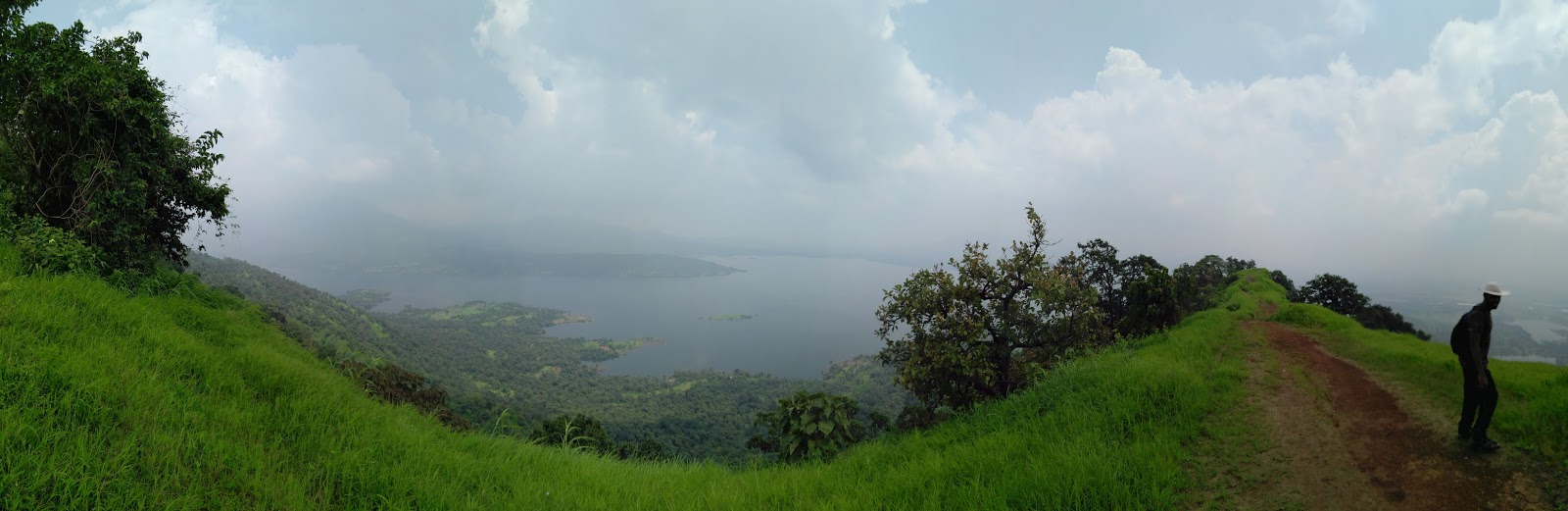 |
| Panoramic view from the Irshalgad |
Irshalgad a 3700 feet pinnacle is located in the Panvel region among the three other forts Kalavantin, Prabalgad and Karnala. Irshalgad is not a fort but a pinnacle and a must trek destination in the list of trek lovers. Not much of a history is associated with Irshalgad and nothing is mentioned about it in the history books. Irshal in Irshalgad means Pinnacle and gad means fort. It is a sister fort to Prabalgad, both forts are connected by a ridge. Irshalgad is completely open from all sides, no fortifications are seen, hence it is always covered in fog. One can camp at the Irshalwadi village, arrangements can be made by the local villagers who offer food to the trekkers.
How to reach?
Irshalgad can be reached from Panvel or Karjat. From Panvel railway station, one needs to walk towards the Panvel ST depot, which is a 10-minute walk. Catch an ST going towards Karjat. State Transport (ST) buses ply regularly from Panvel to Karjat within a 15-minute interval.
The destination to reach is the Chouk village which is a 40 min ride from Panvel and the ST fare is a mere Rs 20. Ask the conductor to drop you at the Chouk railway station bus stop.
 |
| Panvel ST bus timetable |
 |
| The Chouk ST bus stop |
After reaching Chouk, you need to cross the railway line of the Chouk railway station and get on the other side.
 |
| Getting on the other side of the Chouk station |
 |
| Walking towards Irshalgad |
After walking for 5 mins take the road towards left, one to the right takes you to the Morbe dam
 |
| Diversion - Take left to go towards Irshalgad |
The base village for Irshalgad is Irshalwadi which on the Irshalgad mountain plateau, though one passes through the village of Nanivali en route Irshalwadi. You need to ask directions towards the Irshalgad from the local villagers as the route has twists and turn.
After a walk of 30 min through the Nanivali village, the uphill trail starts which is the start point of the ascend in the trek.
 |
| Ascend starts from this point |
Difficulty Level
This is a tough trek, casual trekkers must go with experienced people while doing Irshalgad; because out of all the treks Irshalgad is always in cloud cover and the route to the top is 80-90 degree steep and hence in monsoon, one cannot find the route easily hence there is a chance of getting lost.
Overall the difficulty level is tough for new people and for seasoned trekkers it is a medium to difficult level trek.
Time to reach the Irshalgad pinnacle
It takes about 2.5 to 3 hrs to reach Irshalgad pinnacle from the Nanivali village and about an hour-and-a half from the Irshalwadi village (which is on the hill).
The Name Irshalgad is given from the Irshalkarni or the goddess Irshaldevi temple at the Irshalwadi village. A left turn should be taken from the temple of goddess Irshaldevi.
 |
| Wooden railings at the Irshalwadi village |
 |
| Irshalwadi village |
The Name Irshalgad is given from the Irshalkarni or the goddess Irshaldevi temple at the Irshalwadi village. A left turn should be taken from the temple of goddess Irshaldevi.
 |
| Temple of goddess Irshaldevi |
 |
| Take left from this temple |
 |
| Route towards the pinnacle covered in fog |
Do not climb the huge boulder rocks, instead, take a left from the side to reach the 'Nedhe' point or the Needle Hole.
 |
| Take a left turn from these boulder rocks |
 |
| Wooden ladder |
A small wooden ladder is installed by the local villagers to reach the top at the nedhe (needle hole).
What to see?
There is not much to see at Irshalgad since this pinnacle is always covered in fog. One can reach the 'Nedhe' while ascending to the Irshalgad pinnacle. The Nedhe can even be seen from the bottom and is a prominent feature of the Irshalgad pinnacle.
 |
| Nedhe at Irshalgad |
 |
| Pinnacle 1 of the Ishalgad |
 |
| Pinnacle 2 of the Irshalgad |
Irshalgad has two pinnacles; the way to reach the second pinnacle is risky and very difficult, with a very narrow way, space only for one foot, so avoid going there in heavy fog and monsoon. Pinnacle 1 is easily accessible, although one cannot climb the pinnacle all the way up to the top without proper gears - ropes and harnesses and professional persons with rappelling experiences. Both pinnacles are inclined to 80 degrees hence please do not try to climb it. It might be very dangerous, few trekkers have lost their lives in trying to do so.
 |
| Wild flowers |
 |
| View of Morbe dam |
 |
| The Morbe dam |
 |
| Splendid view of adjoining hills |
My Experience
For other people, it was just another monsoon weekend, what to do? let us go to some resort and enjoy! they would have said. Weekend enjoyment for me is with a date with nature and admiring her mesmerizing beauty.
Woke up at 3 am in the wee hours of Saturday 10th Sept., (though I never slept the whole night), traveling to Panvel for me is to change three trains, going from western line to harbour, (Kandivali-Dadar-Thane-Panvel). Our group was to meet at Thane station at 6 am and board the 6.19 am local to Panvel. We reached the Panvel station at 7.40 am had breakfast and walked towards the Panvel ST depot. The depot was crowded with lot of villagers traveling to and from Panvel to their destinations. The bus to Karjat arrived at 7.50 am and we reached the Chouk stop at 8.30 am. After walking for half and hour the uphill started and the trek became very tiring as the atmosphere was humid with very less or no brezze. We reached Irshalwadi at around 9.45 am and finished half of the trek. An hour more to go!
 |
| Our group relaxing after reaching Irshalwadi village |
We reached the top of Irshalgad at around 11 am; exhausted, tired and thirsty. Had breakfast with some energy drinks.
 |
| Having Breakfast at top of Irshalgad |
Ours was the only group at that time, we rested for about 45 mins and started the journey back to the base. Descend took about 2.5 hrs as we had a lot of time in hand, we went a little aaramsey and on the way did lots of photography😊.
We reached the Panvel railway station at 3.30 pm and all the guys headed to their respective homes with some amazing experience and photographs 😅.
Summary of this trek
- Nearest railway station - Panvel or Karjat
- Base Village - Chouk/Nanivali/Irshalwadi
- Average Expenditure - Rs 150
- Bus ticket from Panvel to Chouk - Rs 20
- Ascend time - 2.5 hrs
- Descend time - 2 to 2.5 hrs
- Difficulty level - Difficult
Tips
- Carry three liters of water, food and first aid kit
- Wear full sleeves shirts and tracks, avoid three fourths or shorts.
- Use good grip trekking shoes or kitoes.
- Do not climb the Irshalgad pinnacle, unless you have very experienced people with you and proper rappelling gears and ropes.
 |
| People doing such an act are a disgrace. Please do not spoil the forts and historical monuments. They are our own property, our ancestors built them with much pride and preserving them is our responsibility. |
KEEP NATURE AND SURROUNDING ATMOSPHERE CLEAN
Sunday, 13 August 2017
Peb (Vikatgad) - Matheran Trek
 |
| Temple of Pebi Devi at the top most point of Peb fort |
At 2100 feet, stands a tall fort behind the famous Matheran hill station - the Peb aka Vikatgad. Peb is becoming a popular trekking center for people near Mumbai and Pune as it is a one-day journey and is well connected to the nearest railway station of Neral. Have you ever wanted to go from one mountain to another part of the mountain range? Well, Peb provides you with an option of a range trek. From the top of Peb fort, you can walk the entire hill and reach the Matheran hill station.
How to reach?
To reach Peb fort, one needs to board the Mumbai local train going towards Karjat or Khopoli on the Central line. Get down at the Neral station and walk right towards the Matheran taxi stand by crossing the Neral-Matheran platform on the Neral station. The morning train timings for Neral from Dadar are as follows:
- 4.42 am Khopoli Slow local
- 5:06 am Karjat Slow local
- 5:38 am Karjat Slow local
- 6:24 am Karjat Fast-Diva local
- 7:03 am Karjat Fast-Mulund local
Avoid getting late for any trek as earliest you go better the journey.
When you arrive at the taxi stand, you can have breakfast at local restaurants and food shops. The base village for this trek is Anandwadi of Fanaswadi; local autos charge around Rs 25-30 to take you to the base village, which is approx. 4 km from the Neral station. Walking towards the base village may take up to an hour, so a wise option would be to use the local transport which leaves you at the foothills of the fort from where the trail begins.
 |
| Place at which the local Rickshaws will drop you |
 |
| The bridge from where the trail begins |
Difficulty Level
For people with prior trekking experiences, the trek is a medium grade and for a novice or casual trekker, it becomes a medium to hard grade. One can easily get lost in the jungle as the trek to Peb has lots of paths and small trails. Hence if you do not have prior trekking experiences (say of more than 5-7 treks), a wise option would be to hire local guide that costs around Rs 500.
The route towards the Peb fort is also known as the 'Tower Route' as one needs to follow the large electric towers that guide you towards the first half of the trek. The goal is to follow the track besides these towers and reach the second electric tower.
 |
| Tower Route - Towers that guide you during the first part of the trek |
 |
| Second electric tower |
From here on, from the second electric tower the trail is a one-way trail and the difficulty level rises a bit.
 |
| After reaching the second electric tower follow the route in front of the electric tower |
Time to reach the top most point
This trek can take up to 2.5-3 hrs to reach the pinnacle. The rock patches here are quite large, and the distance between them is more hence it becomes very difficult to climb such rocks also they are steep and a majority of the rock patches are in the path of flowing water hence they are slippery. After reaching first huge chunk of boulder rocks, you need to take left and go through a canopy of dense vegetation. |
| Boulder rocks |
 |
| Dense jungle trail begins |
The most difficult part of the trek is the huge 10-12 feet rock patch which becomes difficult to climb or get down even for people with prior trekking experience. Hence one needs to carefully climb this rock patch. A rope is provided here for support but it is loosely bound; hence better to climb with bare hands.
 |
| The difficult 10-12ft high rock patch |
After this rock patch, the climb becomes slightly easy and you encounter iron ladders from where there are stairs that take you to the pinnacle of the fort.
 |
| Iron Ladders |
 |
| Iron Ladders |
 |
| Lord Hanuman carved out of rocks - just after the iron ladder |
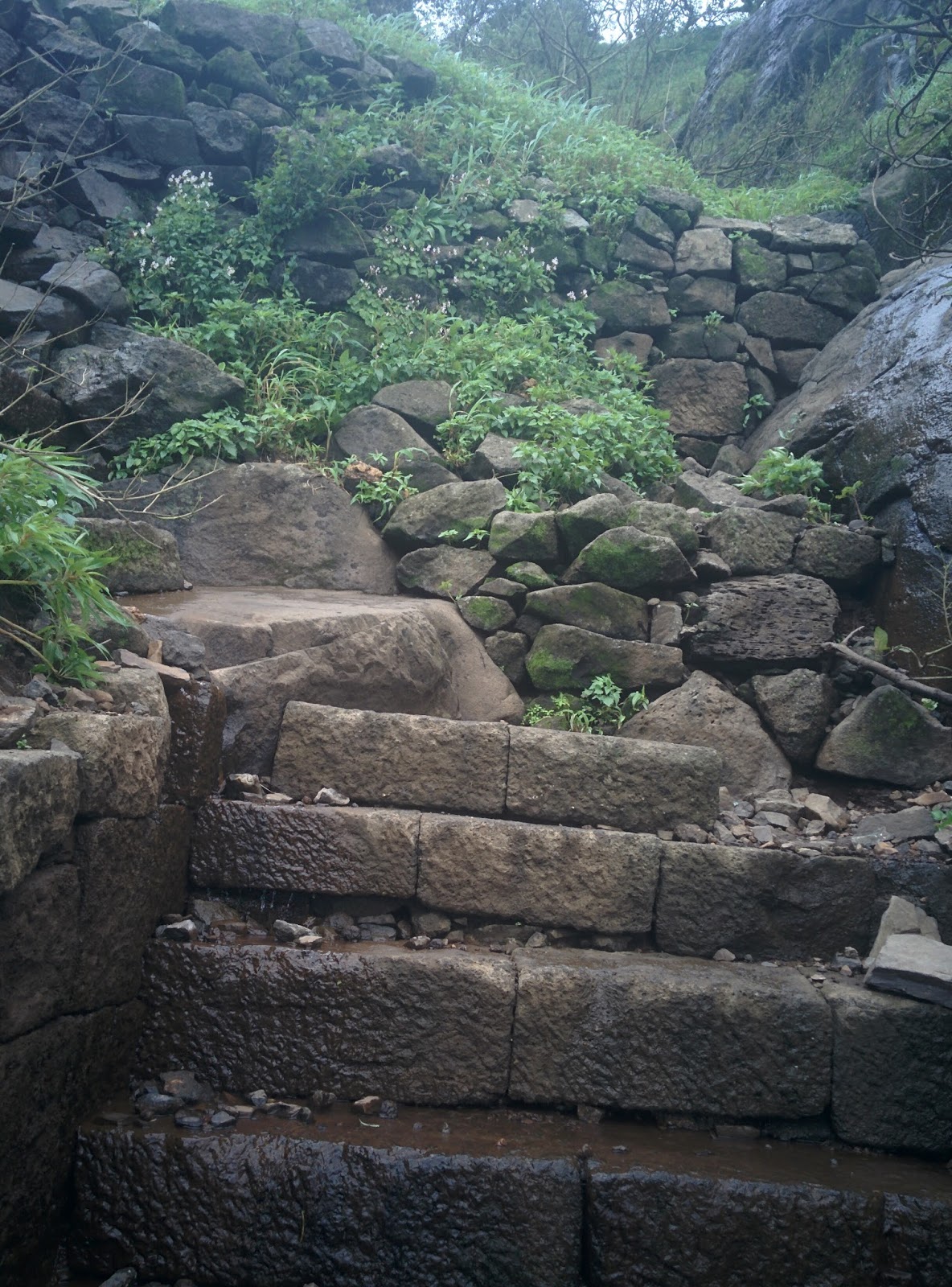 |
| Steps towards the pinnacle of the fort |
What to see
Before the first set of ladders, there are caves which were used to store food grains and ammunition. Also, a cave is dedicated to Swami Samarth Maharaj, however, there is no proper historical mention of him staying here. You can relax here in these caves and overnight stay is possible, with the cave providing a capacity of 25-30 people. When you reach the top there is a temple of goddess Pebi after which the name of the fort, 'Peb' is kept.
 |
| Remains of the fortification |
 |
| Ancient remains of the fort |
 |
| Goddess Pebi temple |
Descend - Matheran Route Details
From the top you have two options, descending down the same route of ascend or travel from one hill to another i.e. from Peb fort hill to Matheran hill. Latter is an easy route and can up to 45-60 mins to reach the Matheran railway tracks. This route starts after a small ladder from this dome shaped gate.
 |
| Gate from where route to Matheran hill station starts |
After 5 mins of walk from this point, a downhill trail is encountered towards the left which takes you to the second set of ladders.


The route from here is simple, no more rock patches or steep climbs, just that the route is narrow with cliff on the side, but easy.
 |
| Final uphill |
 |
| Final ladder of the trek |
After climbing the final ladder you will find the board towards the 'Kadyavarcha Ganpati - Nisarg Raja'. This Ganpati adds to the beauty of the Matheran hill, and stands amidst the beautiful green hills, and hence appropriately named 'Nisarg Raja' or King of the Nature. The view is just mesmerizing!
 |
| Sign board guiding towards Kadyacha Ganpati |
 |
| Kadyavarcha Ganpati |
 |
| Small Ganpati Idol |
 |
| The view of Kadyavarcha Ganpati from the Matheran hill |
The Peb-Matheran trek ends here and after a walk of 15-20 mins along the railway track, a small taxi pickup point is encountered. They charge around Rs 80 per seat and leave you at the Neral railway station from where you can take a train back to home.
My Experience
As decided me and my fellow trekkers (team of six) were to catch the 6:24 am Karjat local from Dadar, which alighted Neral station at 6:44 am. The train was late, it reached 20 mins late at 8:10 am; upon reaching we had the usual breakfast of Misal-Pav, Idli and chai at a local restaurant just outside the station,. After breakfast, we found a rickshaw that was charging us Rs 200 towards the base of the Peb fort, we negotiated with him and finally charged Rs 150. After 25 mins of auto ride, we reached the base village Fanaswadi, the start point of the trek. At about 9 am our trek started. There were multiple paths and trails, we just kept the electric towers as a reference and completed the first part of the trek at around 9:45 am.
 |
| Resting after reaching the second tower |
We acquired speed and started moving quickly. The difficult 10 ft rock high patch was a challenge, but our group of trekkers is a fearless one, nothing could stop us 😄.


We missed the turn towards the Swami Samarth caves and went directly towards the first set of ladders. Next time for sure we gonna visit them when we again do the Peb Trek 😇. At 12 pm we reached the top point, at the Temple of Pebi devi (about 3 hrs ascend), relaxed a bit and started moving towards the Matheran route. Enroute we visited the magnificent Kadyavarcha Ganpati took blessings from the Elephant God and reached the Matheran railway tracks. On the way, a small waterfall was available so relaxed a bit there and started the return journey. A truly mesmerizing experience! Our total expenditure for this trek was about a mere Rs 150 including traveling.
Summary of this trek
- Nearest railway station - Neral (Central line)
- Base village - Fanaswadi or Anandwadi
- Average Expenditure - Rs 150-180
- Difficulty level - Medium for regular trekkers and Hard for casual trekkers
- Route - Follow the three towers from the base village or hire a guide (Rs 500)
Tips
- Descend via the Peb route is difficult; hence always ascend from the Fanaswadi (Tower route) and descend via the Matheran route.
- Peb has multiple paths that might misguide you eventually getting lost, hence ask for directions from the villagers or hire a local guide.
- Carry at-least 3 liters of water, medicines and first aid kit for safety.
- Carry your own food like biscuits, fruits such as bananas, etc.
KEEP NATURE AND SURROUNDING ENVIRONMENT CLEAN
Subscribe to:
Posts (Atom)